-
Shop our Range
▼
-
Deals & Promotions
►
Featured Deals & Promotions
-
Fishing
►
Featured Fishing Categories
-
Boating
►
Featured Boating Categories
-
Marine Electronics
►
Featured Marine Electronics Categories
-
Diving & Snorkeling
►
Featured Diving & Snorkeling Categories
-
Watersports
►
Featured Watersports Categories
-
Apparel
►
Featured Apparel Categories
-
Camping & Hiking
►
Featured Camping & Hiking Categories
-
RV & Motorhomes
►
Featured RV & Motorhomes Categories
-
Hunting
►
Featured Hunting Categories
-
Deals & Promotions
►
-
How Can We Help You?
Give Us A Call 1800 154 713
Or get us to call you...
- Australia's Fastest Delivery with TGE Courier
- Free Delivery on orders over $199* Metro only. T&Cs Apply.
- Full Warranty And No Worries Returns We'll refund, repair or replace
- Insanely Easy Returns via ParcelPoint 1500+ locations Australia-wide
- Lowest Price Guarantee Find a lower price, we'll match it or we can do better!
- Massive Range 21,000+ products in stock ready to ship!
- AfterPay Shop Now. Pay Later.


The item you're looking at is currently unavailable or has limited stock, how about this one instead?

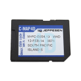
C-MAP MAX Chart Card India / South East Asia SD/MSD
Why pay
$479.00
ONLY
$399.00
SAVE
$80.00!
- Details
-
Details
Customise the way you cruise
This C-MAP 4D MAX Plus Chart Card is the only maritime chart plotting solution that lets you completely customise your navigation charts. With this chart, you can enjoy your time on the water knowing your digital marine charts and GPS maps are based on reliable, updated marine information and navigation.
Marine Cartography that grows with your boating needs
With C-MAP 4D MAX+, you'll enjoy the only maritime navigation chart product that can be customised exactly the way you want. It's the only nautical digital cartography that's actually two products in one cartridge and has the capability of adding new marine chart data as it becomes available. First, choose either the MAX or full 4D content on your cartridge. Should you start out with Max and decide at a later date to upgrade to the full 4D content, simply use the same cartridge to purchase and unlock the additional technology. The C-MAP 4D allows you to unlock or add Value-Added-Data as they become available. Value-Added-Data can be added to either MAX or 4D content.
3-Dimensional Chart View
The world has three dimensions. When you add the 4th dimension of time – meaning consistent, periodic updates – you combine the most detailed 3D height and depth worldwide database with a continuous update process to give you a personalised navigation experience with up-to-date data for safe navigation.
Satellite Images with 2D and 3D Overlay
The C-MAP 4D includes a navigational perspective with high-resolution coastal imagery overlaid on the most accurate and up-to-date vector data, plus thousands of extraordinary photos for the most popular marinas and areas of interest.
Digital Raster Charts with 2D and 3D Overlay
With raster charts, you have an additional reference source for navigational awareness. Get "at-a-glance" information using the nautical paper charts overlaid on the multi-dimensional shaded relief to have a new visual experience.
Guardian Alarm
When activated, Guardian Alarm performs an automatic forward-scanning check for obstacles. Use the feature as an added backup to alert you should you head toward a potentially harmful object.
Easy Routing
Enter start and end points along with specific boat parameters and automatically receive waypoints of the shortest route; highlights potential hazards and displays varying levels of alerts for each segment of the route, allows you to manually adjust the route.
Value-Added-Data
With C-MAP, you invest in a navigation solution that continually evolves. In addition to consistent updates, we're adding new features and new data that deliver useful information, taking your charts to a whole new level.
C-MAP 4D MAX Plus Chart Card Features:
- Superior coastal, intercoastal and waterway maps
- Detailed oceanic and enhanced GPS maritime navigation
- Precise fishing bathymetry and digital raster maps
- Advanced electronic nautical chart plotting
- 3-Dimensional Chart View
- Satellite Images with 2D and 3D Overlay
- Digital Raster Charts with 2D and 3D Overlay
- Guardian Alarm
- Easy Routing
C-MAP 4D MAX Plus Chart Card Specifications:
- Coverage: South Pacific (Wide)
- Format: SD/MSD Card
- Furuno 1670,1870, Raymarine MFD (includes bathymetric data
free)
- Superior coastal, intercoastal and waterway maps
Products You Recently Viewed
-
C-MAP 4D MAX Plus Chart Card South Pacific SD/MSD
 ONLY $449.00
Ships May 4 - May 17