-
Shop our Range
▼
-
Deals & Promotions
►
Featured Deals & Promotions
-
Fishing
►
Featured Fishing Categories
-
Boating
►
Featured Boating Categories
-
Marine Electronics
►
Featured Marine Electronics Categories
-
Diving & Snorkeling
►
Featured Diving & Snorkeling Categories
-
Watersports
►
Featured Watersports Categories
-
Apparel
►
Featured Apparel Categories
-
Camping & Hiking
►
Featured Camping & Hiking Categories
-
RV & Motorhomes
►
Featured RV & Motorhomes Categories
-
Hunting
►
Featured Hunting Categories
-
Deals & Promotions
►
-
How Can We Help You?
Give Us A Call 1800 154 713
Or get us to call you...
- Australia's Fastest Delivery with TGE Courier
- Free Delivery on orders over $199* Metro only. T&Cs Apply.
- Full Warranty And No Worries Returns We'll refund, repair or replace
- Insanely Easy Returns via ParcelPoint 1500+ locations Australia-wide
- Lowest Price Guarantee Find a lower price, we'll match it or we can do better!
- Massive Range 21,000+ products in stock ready to ship!
- AfterPay Shop Now. Pay Later.


The item you're looking at is currently unavailable or has limited stock, how about this one instead?

- Details
-
Details

Fish smarter
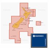
Whether you're on the water or planning a trip, Navionics Plus charts can take you there! The Navionics Plus Regions Chart Card delivers the great value of Navionics Plus in smaller regions at a very convenient price. The new state-based regions represent an easy to understand chart coverage for end users and boundaries have been designed to overlap in popular coastal areas where boaters frequently cross over borders.
Now with SonarChart, this chart lets you see extraordinary bottom contour detail, great for increasing awareness of shallow waters and for locating fishing areas at any depth level. You can also switch to the standard Nautical chart appearance by simply pressing 1 button. The Navionics Plus provides superior detail, shaded depth contours, real-world shapes, colours for buoys and navaids, tide and current data, spot soundings and many more.
Just plug and play into a Navionics compatible plotter and have easy access to all the essential information found on official paper charts and fishing maps. These Navionics charts provide navigators and fishermen all the necessary data for safer and easier navigation.
SonarChart
SonarChart is an HD bathymetry map featuring extraordinary bottom contour detail, great for increasing awareness of shallow waters and for locating fishing areas at any depth level. Target underwater structiure with up to 0.5m HD contours to find the best fishing locations
Navionics Plus Regions Chart Card Features:
- Model number: CF/NAV+NZ
- Nautical Chart, SonarChart and Community Edits in one
card
- High definition layer
- Take advantage of daily updates
- Dock to dock autorouting
- Advanced map option
- Plotter sync
- Format: CF
- Coverage: North and South island including Chatham
island
- Model number: CF/NAV+NZ
Products You Recently Viewed
-
Navionics Plus Regions Chart Card NZ North and South Island CF
 Why pay $329.00ONLY $219.00SAVE $110.00!
Out of stock