-
Shop our Range
▼
-
Deals & Promotions
►
Featured Deals & Promotions
-
Fishing
►
Featured Fishing Categories
-
Boating
►
Featured Boating Categories
-
Marine Electronics
►
Featured Marine Electronics Categories
-
Diving & Snorkeling
►
Featured Diving & Snorkeling Categories
-
Watersports
►
Featured Watersports Categories
-
Apparel
►
Featured Apparel Categories
-
Camping & Hiking
►
Featured Camping & Hiking Categories
-
RV & Motorhomes
►
Featured RV & Motorhomes Categories
-
Hunting
►
Featured Hunting Categories
-
Deals & Promotions
►
-
How Can We Help You?
Give Us A Call 1800 154 713
Or get us to call you...
- Australia's Fastest Delivery with TGE Courier
- Free Delivery on orders over $199* Metro only. T&Cs Apply.
- Full Warranty And No Worries Returns We'll refund, repair or replace
- Insanely Easy Returns via ParcelPoint 1500+ locations Australia-wide
- Lowest Price Guarantee Find a lower price, we'll match it or we can do better!
- Massive Range 21,000+ products in stock ready to ship!
- AfterPay Shop Now. Pay Later.


- Details
-
Details

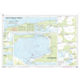
This Imray-Iolaire waterproof chart covers the North Coast of Trinidad as well as the Gulf of Paria between Trinidad and Venezuela. The chart is printed in color and uses official surveys and notes based on local knowledge. It includes large-scale insets of the following bays and ports: Golfo de Paria, Guiria, Ensenada Patao, Ensenada Cariaquita, Macqueripe Bay, Maracas Bay, La Vache Bay, Las Cuevas Bay, Chupara Bay, Grande Riviere Bay, Toco Bay, Matelot Bay, Point Fortin, San Souci Bay, Pointe a Pierre, and Brighton.
Features:- Printed in color on treated, water-resistant paper
- Folded for efficient storage
- Includes protective plastic sleeve
Specifications:- Length: 34.5 in (87.63 cm)
- Width: 25 in (63.5 cm)
- Height: 0.1 in (0.25 cm)
- Dimensions: 25' x 35 1/2' (640 x 900 cm)
- Weight: 0.3 lb (0.25 cm)
- UPC Code: 9780852887127
- HTS Code: 4905.99.0000
Products You Recently Viewed
-
Imray North Coast of Trinidad Chart
 Why pay $91.99ONLY $75.99SAVE $16.00!
Ships Jul 22 - Aug 17